Ask any Floridian about hurricanes and you will get a story. The time the power was out for nine days. The neighbor who taped an X on every window. The cousin who swears the eye passed over and he walked the dog.
Hurricanes are part of life here, so it is easy to think we already know everything about them. But some hurricane facts are so strange they sound invented. They are not. And a few of them say a lot about what your home is really up against.
So grab a cafecito. Here are the hurricane facts worth knowing this October, plus what each one means for a Florida house.
Fact 1: The 2026 Season Went Four Months Without a Single Hurricane
This year was weird. Really weird.
The season opened on June 1 and stayed quiet for months. By late September, the Atlantic had produced several named storms and zero hurricanes. Reporters started digging through century-old records to find anything comparable.
Here is what made 2026 stand out:
- The 2026 season became the first since 1914 to reach September 21 without a hurricane.
- It also set the record for the latest first hurricane of the satellite era.
- A strong El Niño pumped up wind shear across the Atlantic, which tears developing storms apart before they can organize.
Then October showed up.
Tropical Storm Isaias formed in the Gulf on October 7, intensified fast, and became the season’s first hurricane. It came within a day of matching a record from 1905. On Friday night, October 9, Isaias came ashore near Destin as a Category 2 hurricane with 105 mph sustained winds.
What it means for your home: A quiet season is not a safe season. The calendar said “slow year” right up until a Cat 2 hit the Panhandle. Homes are built for the storm that arrives, not the forecast.
Fact 2: Hurricanes Used to Be Named After Saints
Long before the National Hurricane Center existed, people in the Spanish Caribbean had their own system. In Cuba and Puerto Rico in the early 1800s, storms were named after the Catholic saint whose feast day they arrived on.
That system eventually gave way to a few others:
- During World War II, the military used a phonetic alphabet for storms (think Able, Baker, Charlie).
- Starting in 1953, official Atlantic storm names were all female.
- In 1979, male names joined the lists for the Atlantic and Gulf.
Why name them at all? Short, distinct names are easier to say on the radio, easier to write in a warning, and harder to mix up when two storms are spinning at once. Imagine trying to evacuate Broward County because of “the low pressure system at 24.5 north, 78 west.” Not ideal.
Fact 3: There Are Only Six Name Lists, and They Repeat
The World Meteorological Organization, a United Nations agency, manages the Atlantic name lists. There are six lists of 21 names each, and they rotate on a six-year cycle.
That means the 2026 list is basically the 2020 list. The one change: Laura was swapped out for Leah after Hurricane Laura’s destruction in 2020.
A few more naming quirks:
- No Q, U, X, Y, or Z. There are not enough common names that start with those letters.
- Twenty-one names per year. If a season burns through all of them, a supplemental list kicks in. The Greek alphabet used to fill this role, but the WMO dropped it after the record 2020 season.
- Names alternate between male and female through the alphabet.
So if your name is Arthur, Bertha, or Cristobal, congratulations. You get a tropical system roughly every six years.
Fact 4: “I” Is the Unluckiest Letter in Hurricane History
When a storm is so deadly or destructive that reusing the name would be insensitive, the WMO retires it permanently. As of 2026, about 100 Atlantic storm names have been retired.
And one letter keeps showing up on that list. The letter I has been retired more than any other. Floridians know many of them personally:
- Irma (2017) swept nearly the entire state.
- Ian (2022) devastated Southwest Florida.
- Ivan (2004) battered the Panhandle.
- Ike, Isabel, Irene, and others were retired too.
Part of the reason is timing. The ninth name of the season usually shows up near the peak of hurricane season, when the ocean is warmest and storms have the most fuel. The I storm often arrives at exactly the wrong time.
Fittingly, the first hurricane of 2026 was Isaias, the ninth named storm of the year.
The most recent retirement? Melissa, struck from the list in March 2026 after a catastrophic Category 5 landfall in Jamaica in 2025.
Fact 5: The Eye Is Calm, and That Is the Dangerous Part
Every Florida family seems to have the story about someone who stepped outside during the eye.
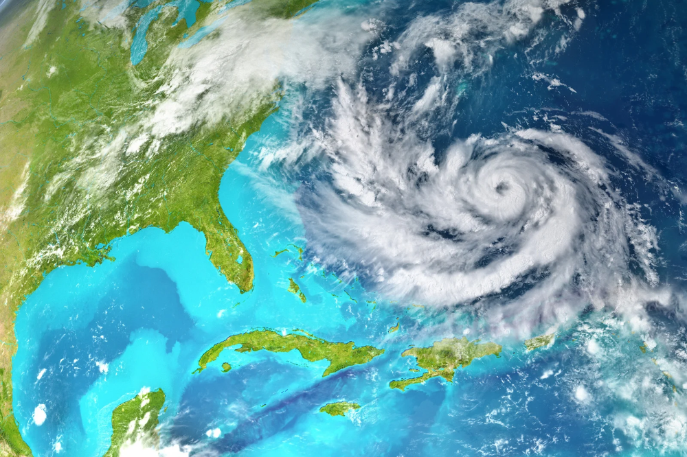
Here is what is actually happening. As a hurricane spins faster, a calm, clear center forms. Air sinks inside the eye, the skies can open up, and the wind can drop to almost nothing. The eye is usually somewhere around 20 to 30 miles wide.
Then the back half of the storm arrives. The eyewall, which holds the strongest winds in the hurricane, sweeps through again. Except now the wind comes from the opposite direction.
That reversal matters for your house:
- A roof that held during the first half may already have loose shingles or lifted edges.
- The second blast pushes on the home from a new angle, testing different windows, doors, and roof edges.
- Debris that piled up on one side gets picked up and thrown back.
What it means for your home: Your roof, windows, and doors have to survive the storm twice. Wind-resistant roofing and impact-rated openings are built for exactly this kind of repeated, shifting pressure.
Fact 6: Hurricanes Spin Counterclockwise, Which Makes One Side Worse
Storms north of the equator spin counterclockwise. Storms south of the equator spin clockwise. Simple enough.
But here is the fun part. Because the storm is spinning and also moving forward, the winds on the right side of its path stack on top of the storm’s forward speed. That makes the front right quadrant the most dangerous part of the hurricane.
For a storm moving north into the Panhandle, like Isaias, the right side lands to the east. That is why communities east of landfall often see the worst surge and wind.
We covered this one in depth in our post on why the right side of a hurricane is worse. Short version: where you are relative to the track matters as much as the category.
Fact 7: A Hurricane Packs More Power Than You Can Picture
Hurricanes are powered by warm ocean water, usually around 80°F or warmer. As warm, moist air rises and condenses into clouds, it releases heat. That heat feeds the storm, and the storm grows.
How much power are we talking about? According to PBS NOVA, the wind of a single hurricane can produce about half as much energy as the entire planet’s electrical generating capacity.
Half. Of the planet. From one storm.
And it is not just wind:
- Hurricanes can spawn tornadoes in their outer rain bands, far from the center.
- Storm surge, the ocean pushed ashore by wind, is the deadliest hurricane hazard.
- Rain can be staggering. Isaias dropped more than 11 inches near Mary Esther in the Panhandle.
Fact 8: Gusts Can Hit Much Harder Than the Category Suggests
Here is a fact that surprises a lot of homeowners. A storm’s category is based on sustained winds, the average speed over one minute. Gusts are short bursts that can be much stronger.
Isaias was a Category 2 with 105 mph sustained winds. But according to the National Weather Service, observed gusts reached 118 mph in Jay and 116 mph at Oriole Beach.
That gap matters. Your roof does not feel the average. It feels the peak. A 118 mph gust is Category 3 territory, even inside a Category 2 storm.
What it means for your home: Roof-to-wall connections, sealed roof decks, and impact-rated openings are tested against those peaks. This is a big part of why Florida’s building code and wind mitigation inspections focus on how a home is held together, not just what it looks like.
Fact 9: There Are People Who Fly Into Hurricanes on Purpose
Yes, this is a real job.
Hurricane hunters are crews who fly specially equipped aircraft straight through the eyewall and into the eye. They drop instruments into the storm to measure pressure, wind, and humidity. That data goes right into the forecasts you see on the news.
Meanwhile, weather satellites watch from about 22,300 miles above Earth. Between the satellites and the hurricane hunters, forecasters can now track storms days before they reach land.
The takeaway for homeowners: you usually get a warning. What you can do in those few days is limited, though. You can buy water and gas. You cannot replace a roof or install impact windows in 48 hours.
Fact 10: Hurricane Season Ends November 30, and October Leans Toward Florida
Hurricane season officially runs through November 30. And October has a habit of being sneaky.
Early in the season, many storms start as tropical waves off the coast of Africa and travel thousands of miles. By October, that pattern fades. The favored zones for development shift west to the Caribbean, the Gulf, and the western Atlantic.
In other words, late season hurricanes in Florida can form close by and arrive fast. Isaias went from tropical storm to Gulf Coast landfall in about two and a half days.
Even in an average year, the season is not done in October. National Hurricane Center climatology shows the average season does not reach its sixth hurricane until around mid-October.
So What Do All These Hurricane Facts Add Up To?
Strip away the trivia and a pattern shows up:
- Storms can arrive in “quiet” years.
- They can form close to Florida with little lead time.
- Gusts hit harder than the category suggests.
- The wind reverses direction and tests your home twice.
None of that is meant to scare anyone. Floridians handle hurricanes better than almost anyone. It is just a reminder that the strongest preparation happens months before a storm, not days.
That is where the roof, windows, and doors come in.
How the Hurricane Safety Program Helps Florida Homeowners Prepare
The Hurricane Safety Program is a private home hardening program that helps Florida homeowners upgrade the parts of the house that take the hardest hits. We work with homeowners across Miami-Dade, Broward, Palm Beach, and Tampa.
We handle everything, start to finish:
- Inspections. We look at your roof, windows, and doors and explain what we find in plain language.
- Permits. We take care of the paperwork with your city or county.
- Installation. Wind-resistant roofing, impact windows, and impact doors installed to Florida code.
- Insurance documentation. Upgrades like these can help your home qualify for wind mitigation credits. Savings depend on your home and your insurer, so they are possible, not guaranteed. We help you get the paperwork your insurer needs to review them.
- Financing. Qualifying homeowners can get financing with no upfront cost.
The goal is simple. When the next Isaias shows up, in a busy year or a quiet one, your home is ready before the first warning goes out.
Check If Your Home Qualifies
You do not need to know your roof’s age, your window ratings, or your current wind mitigation report to get started. We will help you figure that out.
Check If Your Home Qualifies →
Prefer to talk to someone? Call us at (888) 369-4536.